Carlson Software Software to Design and Build Roads
Carlson Software caters for all of your software needs in road construction, whether starting from scratch or resurfacing an old road. From the earliest stages of collecting data, to designing the roadway, estimating the costs and building the road itself, Carlson has the software solutions to meet your needs. Carlson is "for the total project".
Data collection software for maps and CAD drawings
Start with Carlson’s accurate, intuitive data collection software, Carlson SurvCE or SurvPC, and collect critical data throughout your projects. That same data can be transformed into flawless maps and CAD drawings, complete with linework, symbols and points, all layered and drawn when flowed into Carlson’s office design tools, which include Carlson Survey, Civil, Hydrology and Takeoff. These tools are designed to work the way that you want and get your road projects, whatever size, completed faster and to a better quality.
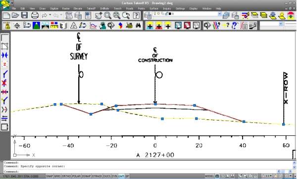
Use Carlson Takeoff to estimate roadways from cross-sections and to prepare models for exact staking or for machine control. With Carlson Grade, the same data is used throughout the project, which enables the operator to execute plans to your specifications.
Data collection software with advanced roading
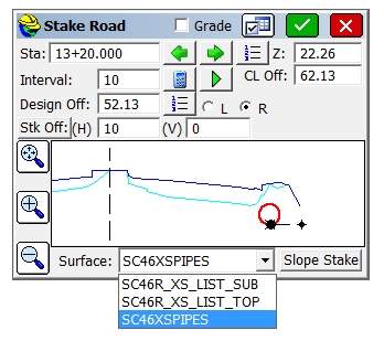
Carlson SurvCE combines advanced functionality, ease-of-use and sheer capability to make it the first choice in data collection software. A complete data collection system for real-time kinetic (RTK) GPS and total stations with in-field coordinate geometry, Carlson’s SurvCE supports the widest range of popular RTK GPS and conventional / robotic total stations. Add in the advanced roading option and the user can edit centerline and profile data, draw profiles and perform slope-staking functions directly in the SurvCE software.
Carlson SurvPC data collection software, which can be used on standard Windows PC computers, has recently been updated to enable the land surveyor to work in the GIS environment. This enables crews to access Esri or other GIS source data in the field.
In the new ArcGIS-enabled version of Carlson SurvPC, Esri’s Desktop can be used intuitively to perform all survey functions, ArcGIS points, lines and polygons for staking, ArcGIS Nodes for resections and localisation, and users will be able to query GIS feature attributes at any time with the Store Points, Stake Points and Map View screens. SurvPC is a complete data collection system for RTK GPS and total stations with in-field coordinate geometry.
2D and 3D road, intersection and cul-de-sac design
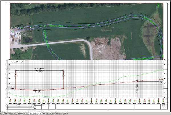
The versatile Carlson Civil desktop design software comes with IntelliCAD 7.2 built in and works on AutoCAD (and Civil3D), versions 2004 to current. With the RoadNETwork aspect of Carlson Civil, users are able to design and dynamically change all roads, intersections and cul-de-sacs in both 2D and 3D with a single click of the ‘process’ button.
Among the newest improvements to Civil’s RoadNETwork is vehicle path tracking with trailers, which allows designers to see wheel paths for vehicle dimensions along a centerline. This is combined with support for vehicles with hinge points and save / load vehicle dimensions, which allows clients to see truck paths on sites and road designs to make sure the turning radius will work.
Another recent addition to Carlson Civil is the ability to produce a geometric best-fit shape of the existing road for use with a string-less paving system. The new routines developed include creating a rehab profile based on milling, leveling and overlay parameters, best-fit profile, best-fit centerline and template grade table method to reference existing sections to set cross slopes.
Reduced need for on-site personnel
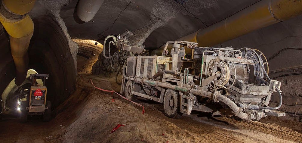
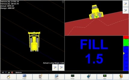
If you use machine control from Carlson, you’ll find the need for staking, on-site inspection and oversight greatly reduced. In addition, this also increases safety on the worksite. Carlson Grade, premier 3D machine control software, supports most heavy machine types, sensors and the world’s largest GNSS library. With Carlson Grade, users get real-time cut / fill across the entire project, volumes daily, weekly or any time, 3D volume reports output to PDF, ability to directly import .dwg, .dxf, TN3, GC3 and LN3, and grade check for all machines.
Using Carlson Takeoff to prepare your paper plans or electronic designs for machine control is both easy and time-saving. The newly released version of Takeoff will provide better reporting with new direct PDF output for cut / fill volume reports, 3D surface models, surface profiles, site plan views and cross sections, plus increased 3D visualization. Also expect more compatibility with best-in-the-business cross-section processing, PDF and TIF file import and .dgn file support.
Total highway design and construction cycle
Carlson Software, an independent family-owned company since 1983, is here for your land surveying, civil engineering and construction needs with its affordable, technically advanced software. Carlson’s top-rated customer service consists of real people ready to take your call, ready to get you back to work.
Carlson Software Images


Products and Services
Video
White Papers
Related Projects
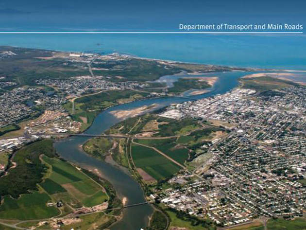
Mackay Ring Road, Queensland, Australia
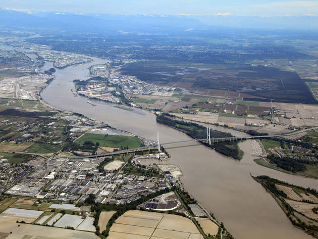
George Massey Tunnel Replacement Project, British Columbia, Canada
Press Release
Regional Offices
102 West Second Street
Maysville
41056
Kentucky
United States of America